
Everything is Connected on the Kim Nicol Trail
The more I learn about the Coachella Valley, the more I love and appreciate how our diverse landscapes and rich pockets of unique species are interconnected. A great place to explore these connections is on the Kim Nicol trail near Desert Hot Springs. One of the desert's newest trails, is named in honor of the California Department of Fish and Wildlife Regional Manager who dedicated her life to the conservation and preservation of the Coachella Valley desert habitat. The Kim Nicol trail offers fantastic 360 degree views of the valley, awesome rocks (geology!), and is the only place in the world where you can go on an unsupervised hike and see the endangered Coachella Valley fringe-toed lizard, Uma inornata, and see the sand that ties them all together.
Right at the trailhead you are treated to a great view of Mount San Jacinto’s grand height, which subjects our valley to a rainshadow effect. Rainfall from the Pacific Ocean is stopped by the mountains before reaching the Coachella Valley, creating an arid desert region. Though it might all be arid and hot, reaching temperatures of up to 120℉ degrees during the summer, this is the junction of several different deserts, the Transverse Mountain Range Extension, and the Baja Mountain Range Extension.
The first part of the trail follows a dry wash, which is a dry stream channel full of rocks. The rocks here are both beautiful and tell interesting stories about the land around us, and if you are anything like me you might spend more time than you anticipated right at this location.

Sedimentary rocks tell the history of the Earth, and metamorphic rocks, with their light and dark wavy bands give us clues to the great pressure and heat that was needed to create those formations, like the forces that accompany the grinding action of the North American tectonic plate and the Pacific tectonic plate, which formed the Little San Bernardino Mountains to the north of the trail. One of the more interesting rocks I’ve come across here, and a great example of metamorphic forces, is garnet. Garnet that is found near the Earth’s surface forms when a sedimentary rock with high aluminum content, such as shale, is subjected to intense heat and pressure to produce schist and gneiss, which are plentiful in the dry wash.
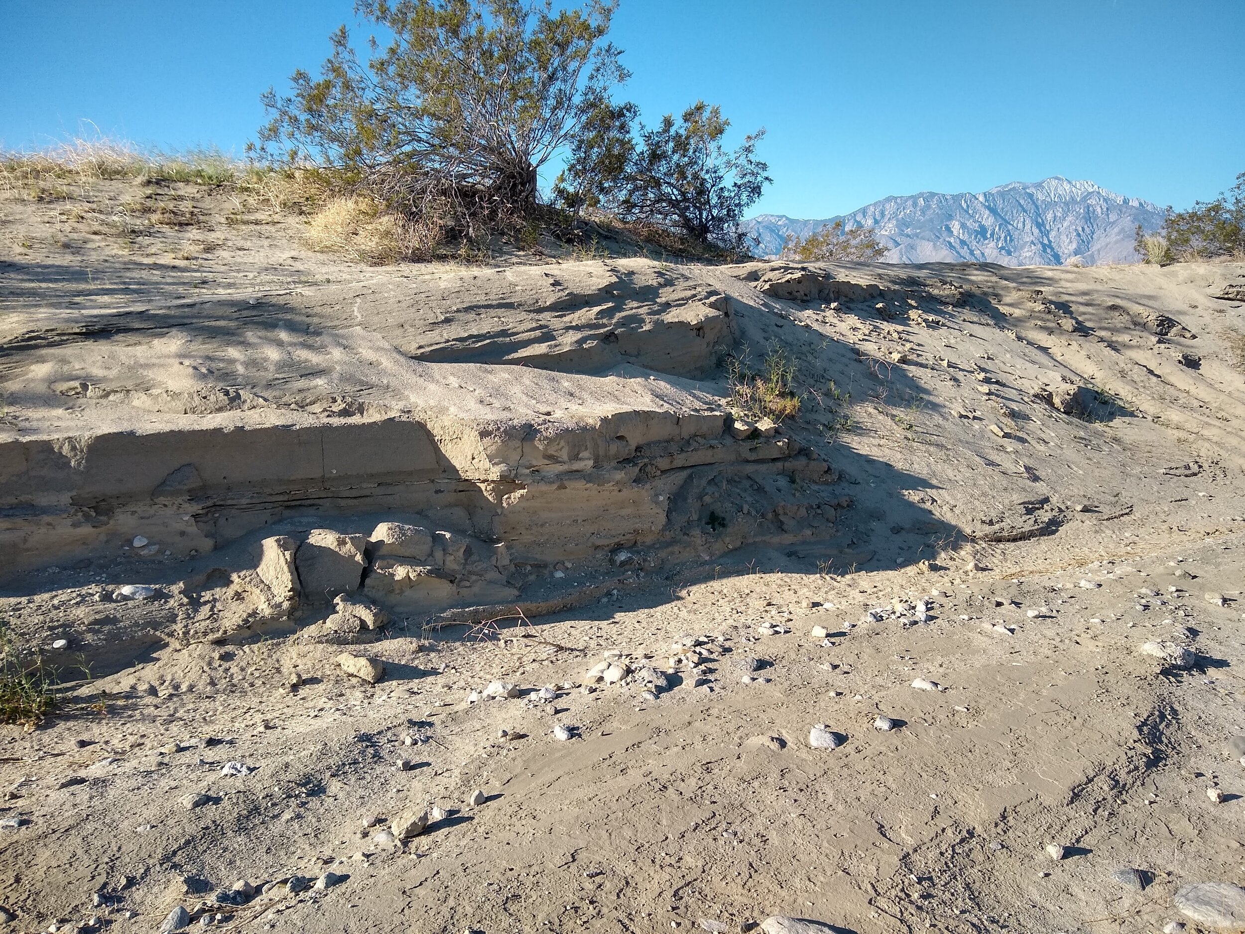
If and when you are able to break free from the lure of all the shiny rocks at the beginning of the trail, continue on to find layers of sand and rocks on the sides of the trail. Typically not enough rain falls in arid deserts for a continuous stream to flow, so the stream deposits its load of sediments near the mountain front and spreads out over a broader region in a wedge-shaped apron of gravel and sand called an alluvial fan. Flash floods then carve steep-sided channels into the ground, and sand-laden water polishes the bedrock walls and creates grooves. On the trail you will see evidence from the February 14, 2019 flash flood which carved channels and exposed sedimentary layers created from previous deposition of the Little San Bernardino Mountains.
You will leave the canyon via a steep incline, one of the trickier spots on the trail, filled with soft sand. In fact, you may find yourself cursing all of the sand on the Kim Nicol Trail, but keep in mind that sand in the Coachella Valley is very special. This is one of the few locations in the world where the sand comes primarily from the erosion of granite. I personally love how our desert sand glitters in the sun, reflecting quartz grains and mica flakes - the same mineral used in cosmetic glitters and makeup, but our desert is just naturally beautiful.
But how did the sand get here? Sand movement in our desert is carried in a North West to South East direction. The desert rainshadow effect contributes to strong winds in the Coachella Valley as hot air rises, pushing sand and dust away from the alluvial fans at the base of the mountains. The lighter dust gets carried away and the remaining well-sorted sand accumulates in dunes. Thus, thick layers of well-sorted sandstone, in which we see large cross beds are relics of desert-sand dune environments. Sand dunes used to dominate the Coachella Valley once covering 100 sq. miles from the San Bernardino Pass to Indio.
As you climb up and up, keep an eye out for another of the fantastic rewards of this trail - lizards! You might think of the desert as barren, but the Coachella Valley is particularly rich in lizards, with 33 different species found within a 50 km radius - the most of anywhere in the United States!
Many of these species have developed specialized adaptations to survive in the desert and are endemic, or found nowhere else on Earth, like the Coachella Valley fringe-toed lizard. As their name implies, a unique feature of this lizard are the fringes on the edges of their toes. These fringes give them the unique ability to walk quickly over hot sands without sinking. Other adaptations include a wedge-shaped nose which enables it to burrow through loose sand with specialized nostrils that allow it to breathe without inhaling sand particles.

In 1980 Coachella Valley fringe-toed lizards were designated an endangered species with the help of the “Lizard Club,” and was the first of 26 species to be protected under the Coachella Valley Multiple Species Habitat Conservation Plan. The plan was created in response to urban sprawl which has greatly affected the flow of sand in our valley. Today, 95% of sand dunes are gone, and the Kim Nicol trail is the last place you can view the Coachella Valley Fringe-toed Lizard without restricted access, a very unique and exciting experience!
At the high point of the trail you can enjoy 360° views of the desert, Mount San Jacinto, Mount San Gorgonio, the Little San Bernardino Mountains, and even visualize how sand flows through the desert - from the peaks of the mountains, through alluvial fans and along the windy pass to the dunes where fringe-toed lizards roams. Everything is connected!

When you are done admiring the view, look down at your feet for one more geologic feature of the trail. Over long periods of time, wind abrasions create smooth surfaces, or facets, on pebbles, cobbles, and boulders. If a rock rolls or tips relative to the prevailing wind direction, after it has been faceted on one side or if the wind shifts directions, a new facet with a different orientation forms, and the two facets join at a sharp edge. Rocks whose surface has been faceted by the wind are called ventifacts, and there are many of them here along the trail.
From here, you can return along the same route or complete the loop on the the latter half of the trail, which will take you through even more beautiful sand dunes, and more chances to see a variety of lizards. I hope that you enjoyed reading about this awesome trail, and if you get a chance to hike it, good luck getting past the dry wash!It has taken me several attempts before I’ve been able to successfully finish the loop. A great goal is to at least make it to the high point so you get a chance to view the desert, visualize how sand travels through the valley, and even spot the endangered lizard and perhaps see sand in a different way.